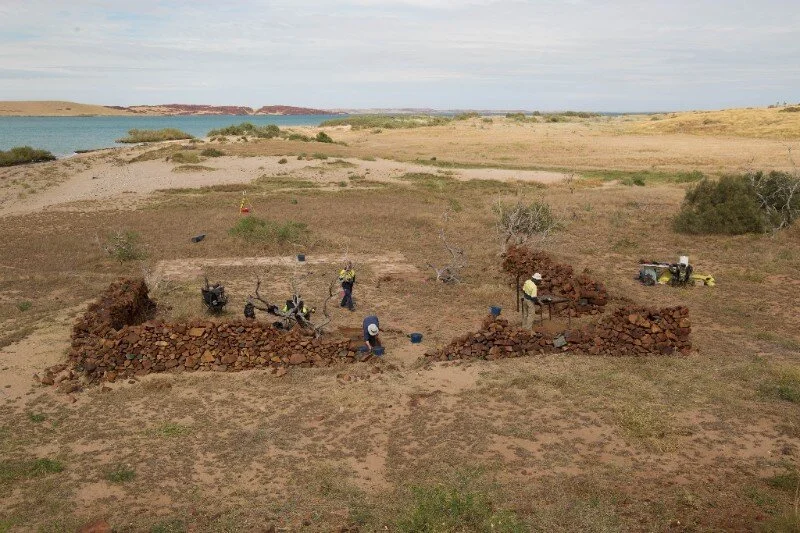
9000 -year -old Stone Houses and the first submerged ancient archaeological sites found on the seabed in Australia.
Located in Western Australia. Rosemary Island and the surrounding islands, along with the Burrup Peninsula, are collectively Murujuga (meaning 'hip bones sticking out) in the local language of the Ngarluma, Yindjibarndi. Member groups who make up the Murujuga Corporation. Their ancestors have been carving their stories and working with stone for thousands of years. There are standing stones, middens, Artefact scatters, and stone houses built. One site contains the densest number of standing stones on the island - 34 standing stones in about 12 car parking spaces.
In 1699 the English navigator and pirate William Dampier, in command of the 26-gun warship HMS Roebuck on a mission to explore the coast of New Holland, arrived on the Dampier Archipelago on August 21st 1699 naming Rosemary Island. During World War 2, an airstrip was also established at the island's north end.
In 2017, archaeologists identified engravings left by crews of American whaling ships in the 1850s on Rosemary Island, some even engraved over the top of rock art done by the original ancestors of Murujuga.
Archaeological excavations on Rosemary Island have reported evidence of one of Australia's earliest known domestic structures, dated between 8000 and 9000 years ago.
Stone buildings and sheep pens have also been excavated on West Lewis Island from setters in the 1870s to early 1890s.
West Lewis Island - West Lewis Sheep Station Stone building and sheep-pens found, University of Western Australia - Image may be subject to copyright.
Although similar domestic structures are found across Australia, none have been confirmed anywhere near as old. From identifying a mangrove known to be eaten by original people within the houses, researchers could estimate the age of the formations to date back to around the end of the last Ice Age. Murujuga lies within a low-lying floodplain, skirting a tidal-dominant continental shelf. The archipelago and other islands of the Shelf host one of the most significant long-term records of aboriginal adaptation to fluctuating sea levels in Australia. Recent studies illustrate how the original people constantly adapted to the coastline's dynamic environments from before and after the Last Glacial Maximum.
Submerged ancient archaeological sites
A new study published this year, reports the first submerged ancient aboriginal archaeological sites found on the seabed, in waters off Western Australia. For the past four years, a team have been funded to record submerged archaeological sites in conjunction with the Murujuga Aboriginal Corporation off the Pilbara coast in WA. Over a decade, there has been an acceleration of interest in, and expansion of knowledge of submerged archaeological sites in areas once thought unlikely. Most underwater sites have been discovered by chance rather than by survey—reports from divers, artifacts by fishermen, or erosion and exposure due to sea action. Previously, dive surveys at depths 10–20 m below the surface did not reveal any engravings but confirmed that some rock faces are free of marine growth. Whether or not Murujuga’s engraved rock art survived remains to be investigated.
A range of remote sensing hardware and software technologies are being used to locate, characterise and document these original cultural sites of significance in the Pilbara, specifically Murujuga.
We acknowledge the people and elders of Ngarluma Country, including member groups Yinjibarndi, Yaburara, Mardudhunera and Wong-Goo-Tt-Oo, who make up the Murujuga Corporation.
If you enjoyed this article, please support us and share >
Sources and further information:
Paterson, A., Anderson, R., Mulvaney, K., De Koning, S., Dortch, J., & McDonald, J. (2019). So ends this day: American whalers in Yaburara country, Dampier Archipelago. Antiquity, 93(367), 218-235. doi:10.15184/aqy.2018.186
Dortch, C.E. 2002 Preliminary underwater survey for rock engravings and other sea floor sites in the Dampier Archipelago, Pilbara region, Western Australia. Australian Archaeology 54:37-42.https://doi.org/10.1080/03122417.2002.11681739.
Evidence for stone buildings - McDonald, Josephine & Beckett, Emma & Hacker, Jorg & Morrison, Patrick & O’Leary, Michael. (2020). Seeing the Landscape: Multiple Scales of Visualising Terrestrial Heritage on Rosemary Island (Dampier Archipelago). Open Quaternary. 6. 10.5334/oq.81.
Peter Veth, Jo McDonald, Ingrid Ward, Michael O’Leary, Emma Beckett, Jonathan Benjamin, Sean Ulm, Jorg Hacker, Peter J. Ross, Geoff Bailey. (2020) A Strategy for Assessing Continuity in Terrestrial and Maritime Landscapes from Murujuga (Dampier Archipelago), North West Shelf, Australia. The Journal of Island and Coastal Archaeology 15:4, pages 477-503.
Nicholas C. Flemming. (2020) Global experience in locating submerged prehistoric sites and their relevance to research on the American continental shelves. The Journal of Island and Coastal Archaeology 0:0, pages 1-24.
Korff, J 2020 - Aboriginal houses
The University of Western Australia - People inhabited Dampier Archipelago before last ice age
Murujuga Aboriginal Corporation – http://www.murujuga.org.au/
Archaeology and rock art in the Dampier Archipelago - 2017 draft -PDF
The conversation - Cave dig shows the earliest Australians enjoyed a coastal lifestyle
Australian Geographic - Why murujuga needs world heritage status
UNESCO - Murujuga Cultural Landscape
Australian Heritage Council - National Heritage Assessment
ANU - Archaeologists find world’s oldest ground-edge axe in Australia
Oral History - How oral cultures memorise so much information and American Association for the Advancement of Science - Is an Aboriginal tale of an ancient volcano the oldest story ever told?
More videos >
National Trust WA (youtube) Part 1 - Art and Archaeology of the Dampier Archipelago
National Trust WA (youtube) Part 2 - Art and Archaeology of the Dampier Archipelago


